<body><script type="text/javascript"> function setAttributeOnload(object, attribute, val) { if(window.addEventListener) { window.addEventListener('load', function(){ object[attribute] = val; }, false); } else { window.attachEvent('onload', function(){ object[attribute] = val; }); } } </script> <div id="navbar-iframe-container"></div> <script type="text/javascript" src="https://apis.google.com/js/platform.js"></script> <script type="text/javascript"> gapi.load("gapi.iframes:gapi.iframes.style.bubble", function() { if (gapi.iframes && gapi.iframes.getContext) { gapi.iframes.getContext().openChild({ url: 'https://www.blogger.com/navbar/1329707403048224466?origin\x3dhttp://geographeee-enqi.blogspot.com', where: document.getElementById("navbar-iframe-container"), id: "navbar-iframe" }); } }); </script>
please scroll all the way down for all the posts (: for previous posts, they're under 'archive.' on the right-hand side
geographeee.
4:05 AM : Wednesday, August 24, 2011
Geography Assignment (20 Aug 2011 Field Trip)
Research topic
Flooding in Singapore

Hypothesis
There are low-lying areas along East Coast Beach that are prone to flooding.

What I need to find out
-Evidences of low-lying areas
-Flooded areas/wet soil/wet sand/wet rocks/erosion
-Land inclination angle
-Structures with evidence like erosion (concrete, cement) & weathering
-Measures taken to prevent flooding (structures like breakwaters or plants)
-Interviews with regulars at East Coast Beach

Methodology/Steps/Procedures
1. Walk around the beach.
2. Notice the changes in the colour of the sand (whether the colour darkens).
3. Note the length from the sea of where the colour changes.
4. Walk towards the front of the beach (as close as possible to the sea).
5. Look at the general view of the beach/park (the buildings, structures on the land).
6. Walk around and look for flooded areas as well.

Land inclination angle
1. Stand on higher ground (eg. a breakwater).
2. Using a tool made of a protractor, an eraser, a straw and string, look through the straw.
3. Determine the angle of land inclination.

Evidences in structures
1. Walk around and look at the structures.
2. Look out for structures that have eroded surfaces.
3. Look out for pavements/etc. that have erosion too.
4. Notice the differences in colour on structures like breakwaters (may indicate sea level).
5. Note the different trees and plants as well.

Evidences on preventing flooding
1. Walk around and look out for structures that help to prevent flooding or help to reduce flooding (things like drains, trees, breakwaters, seawalls, etc.).

Interviews
1. Interview the people at East Coast Beach, especially those who work there or go there regularly on:
-How often it floods
-Heavy rainfall?
-High tides?
-Do the shops get flooded?
-When was the last flood that took place?
-etc.

Sharing of Findings
Before we actually went to search for evidence, here are some of the knowledge and information we knew beforehand:
-Monsoon season is from about November to February
-On 5 March 2006, it was reported that some parts of the park are experiencing soil erosion which caused certain beachfront areas to collapse. One of the reasons were global warming which has resulted in a higher sea level, thus bringing the coast further inland.

First, we went to the front of the beach to get a general view of the park from the beach.
Here is a bird's eye view of the order:


Then, we walked along the beach spotting for any evidences of flooding. One example is erosion. This concrete pavement has been eroded. It should be because of flooding and over time it has eroded.


Trees have been planted to prevent sand erosion. The roots help hold the sand together thus the sand will not erode and go to the sea during flooding. The picture is not that clear but there is a difference in colour in the trees. The bottom part is darker and it also seems that the bark at the bottom has been eroded (is that possible?).
Thus this shows flooding does take place since the trees are a prevention measure.


Buttress roots can be seen in the photos. This is evidence of flooding as the soil on top of the roots have been washed away by the water. Because of the soil erosion, the buttress roots are exposed and can be seen clearly.


Note the colour changes in the breakwater. The darkened part indicates how high the sea level rises. This could be evidence of flooding as that level is definitely higher than the ground level thus when the sea level reaches that level it will flood.
The presence of the breakwaters are also evidence that flooding takes place there. In order to prevent flooding, the government could have built the breakwaters .


The photo shows an eroded breakwater. When waves hit the breakwater, they lose energy, sediments are deposited and a sandbar is formed. Thus there is sand can be seen on the breakwater. Hence this shows that flooding has taken place as well.
The inclination from this breakwater to the newer breakwater in front of the eroded one is 80 degrees.


The colour changes in the sand also indicate how far the tide can go. The clear line between the darkened part and the lighter part of the sand shows that the water can actually go that far normally.


The presence of these drains indicate that there is flooding. The drains are there to drain away the water, thus it shows that flooding takes place in East Coast Park. There might have been flooding previously which may be the reason why drains have been placed there.


This drain shows the possible flood water level (it is higher than the ground level). Sand covers the drain holes on all sides. The sand might have been blown by the wind, or been swept by the water during flooding, thus covering the drain holes.


Rubbish, seaweed and different sediments from the sea on the beach indicates how far the seawater goes.


The presence of sand on the jetty could be because of flooding. The sand may have been washed up by the water onto the jetty. Thus flooding could have taken place.


The first photo shows the left side of the the jetty. The second photo shows the right side of the jetty. On the left side of the jetty, there are a lot of rubbish, seaweed, sediments, etc most likely washed onto the shore by the water. However, on the right side of the jetty it is very clean. Furthermore, the coastline on the left side is further inland than the coastline on the right side of the jetty. This shows that flooding takes place on the left side.

The sketch below shows a rough estimate of the coastline comparison.

We interviewed a cleaner that was cleaning up the rubbish on the beach. He was from China so we had a bit of difficulty communicating with his accent but we managed to learn that the rubbish was on the beach often (it appears frequently because of the sea and most probably flooding) which is also why cleaners have to be hired to clean the beach. This is evidence of flooding too.

We did not manage to interview the shopkeepers though because they were too busy.

Also, another reason why there might be flooding may be because of rainfall. Flooding may not necessarily be because of the sea all the time.

Therefore, after analysing the evidence at East Coast Beach, I can conclude that there are low-lying areas along East Coast Beach that are prone to flooding, and that flooding does take place at East Coast Beach.

Reflections
The trip to East Coast Beach was definitely a memorable and educational experience. It made me see the park in a different light.
Unlike the previous times I went there for leisure, this time I went with a different purpose and mindset. I learnt many new things and had the opportunity to experience what I have learnt in class first-hand.
For example, I learnt about erosion and flooding, but never got to see it for myself. Also, even though I knew (through common sense) that it does flood in East Coast Beach, I did not know the reason why and did not check it out for myself.
This trip made me feel like a detective in some way, checking for evidences :D
I also understood more about Singapore and our beaches and coastal areas.


-Pae En Qi (29), Sec 2-1 ACE Geography

0 Comments:

    Post a Comment


    << Home

    Chapter 8 Summary (Water Resources)
    Chapter 8: Water Resources

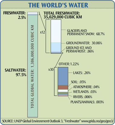
    Water is a scarce resource
    -for drinking, agriculture, industries, other uses like cooking, cleaning, etc.
    -amount of water consumed is increasing, but fresh water available is limited
    -water shortage also refers to water constraint
    _______________________________________________________

    Reasons for water constraint

    1)Limited supply of fresh water

    1. Uneven distribution of fresh water
    -some countries have abundant supply, some have lack
    -eg. Canada has 20% of world's fresh water, India has only 10%
    -may be due to differences in climate
    -eg. lack of rain in some countries in Africa

    2. Water pollution
    -not all water is safe for drinking/other uses
    -polluted by human activities
    -water from factories/households often dumped into rivers
    -eg. Lake Baikal in Russia which stores about 20% of world's fresh water supply is now heavily polluted by discharge of waste chemicals

    2) Rising demand for water
    1. Population growth
    -over past 80 years, world's population tripled & demand for water increased more than 6 times
    -total supply of fresh water have to be shared among more people
    -worsen problem of water constraint in many countries

    2. Growth of agriculture
    -increasing need to grow more food to feed growing population
    -up to 3/4 of world's fresh water supply used for watering of crops & rearing of livestock

    3. Growth of industries
    -eg. water used for cleaning, cooling machines, making products like food, etc.

    4. Changes in lifestyle
    -when country is more developed, people adopt modern lifestyles
    -people can afford to buy items that give more convenience & greater comfort
    -eg. electrical appliances like washing machines & air-conditioners
    -use of these items lead to increase in demand for water
    _____________________________________________________________

    Responses to rising demand for water

    Increasing the price of water
    -people who do not want to pay more will be encouraged to use less water
    -price increase may reduce cost of producing & distributing water
    -poor will suffer more as only rich can afford to use any amount of water they want

    Increasing the supply of water
    1. Increase catchment areas
    -catchment area: area over which rain falls & is collected
    -more catchment areas, more water collected
    -eg. Singapore's Central Catchment area (Upper Seletar Reservoir, etc.)
    -nature reserves often used
    -rainwater intercepted by trees/plants, then absorbed by soil layers on ground
    -water eventually drained into reservoir for storage
    -advantages: increase water supply, reduce water treatment cost, conserve more forests
    -disadvantages: less land for other uses, when there's drought/little rainfall, catchment areas will be ineffective

    2. International agreements
    -international agreement on water: arrangement between 2 or more countries regarding supply & use of water resources over a specific period of time
    -countries discuss & negotiate terms on buying/sharing of water resources
    -eg. Bangladesh-India water treaty signed in 1996
    -advantage: convenient way of obtaining water
    -disadvantage: not a good long-term solution, agreements expire

    3. Use of technology
    -to create new sources of water

    1. Recycling water (water reclamation)
    -used water converted into usable water
    -used water collected from households/factories & channelled to water recycling/water reclamation plants
    -impurities removed
    -end product referred to as recycled water or reclaimed water
    -eg. Singapore's NEWater
    Stage 1) Water is passed through microfiltration where larger particles & bacteria are removed
    Stage 2) Reverse osmosis removes very small particles like bacteria & dissolved salts
    Stage 3) Water disinfected using UV radiation


    2. Desalination
    -desalination: process of removing salt from sea water
    -commonly used in many dry regions & in areas with contaminated water supply
    -eg. Saudi Arabia has one of world's largest desalination plant
    -various methods like distillation & reverse osmosis


    -very costly & requires large amounts of energy
    -eg. NEWater plant at Bedok costs $6.82million while SingSpring Desalination Plant in Tuas costs $200million
    -people not used to idea of drinking the water (different taste, etc.)
    _____________________________________________________________

    Conserving water
    -water conservation: careful use of water resources to ensure that wastage is kept to a minimum
    -supply of clean water is limited & can run out
    -water conservation reduces risk of future water shortage
    -encourages people & industries to use less water
    -delays need to develop/upgrade facilities to increase water supply
    -saves money through reduced water bills
    -campaigns to educate public


    Pae En Qi (29), Sec 2-1


    0 Comments:

      Post a Comment


      << Home

      Chapters 7 Summary
      Chapter 7: Land Supply

      Land is a scarce resource
      -enables us to meet our needs (food, shelter, etc.)
      -growing crops, building houses & roads, setting up industries
      ___________________________________________________________

      Land Constraint


      -growing world population, leading to increasing demand for land (for housing, farming, etc.)
      -limited land in every country, thus there is scarcity of land (land shortage)
      -limit to amount of land that can be developed for different uses (land constraint)
      -2 main reasons: rising demand for land & limited supply of land

      1) Rising demand for land
      1. Population growth
      -more people, more land needed for human activities
      -all areas have carrying capacity
      -more people, available resources have to be shared among more people
      -adds pressure to land

      2. Increasing demand for housing
      -growing population means more houses needed for more people
      -eg. HDB flats are built to meet increasing demand for housing

      3. Growth of industries
      -need to provide jobs for growing population
      -thus, more industries & businesses need to be developed
      -eg. manufacturing industries take up over 10% of Singapore's total land area
      -more land needed to expand industries

      4. Development of transport systems
      -more developed country, more roads & railways needed
      -transport important for country
      -eg. in some cities, over 20 of total land area set aside for transport facilities

      5. Increasing demand for arable land
      -needed to produce food to feed increasing populations
      -arable land is in short supply
      -over 4/5 of earth's land surface unsuitable for growing crops

      6. Increasing demand for recreational spaces
      -more people, more recreational spaces needed
      -eg. swimming pools, parks, etc.
      -for people to enjoy & relax in

      2) Limited supply of land
      -30% of earth's surface, only part the 30% is available for use
      -areas unsuitable for use or of little use (eg. swamps, marshes, low-lying coastal areas, deserts, damaged land due to mining/poor farming practices, etc.)
      -land reserved for other uses (eg. water catchment areas, military purposes)
      -eg. military training areas & water catchment areas in Singapore take up more than 50% of
      total land
      __________________________________________________________

      Responses to rising demand for land
      -increased competition between different groups of people
      -decisions on how pieces of land are to be used
      -opportunity cost: cost of not being able to use same piece of land for next best use
      -eg. opportunity cost of having a nature reserve is having less land for housing
      -thus, land constraint must be managed properly

      1) Increasing the price of land

      -increased demand, increased price
      -some users may be willing to pay higher price for available land, thus leading to increased price
      -price mechanism: way in which prices for goods & services are set based on demand & supply
      -eg. land in city area is usually very expensive. eg. it costs $1600+ a month to rent a one-bedroom apartment in Central Tokyo
      -increasing price of land discourages some people from using land, thus reducing demand

      2) Increasing the supply of land
      1. Land clearance
      -land clearance: process whereby empty plots of land are created for various land uses
      -demolishing old buildings, clearing forests (deforestation)

      -eg. when old buildings are demolished, more land is available to build new buildings/facilities
      -negative impact on environment
      -eg. deforestation destroys habitats of plants & animals
      -negative consequences for food chains

      2. Land reclamation
      -land reclamation: creation of dry land from area covered by water/process of recovering land that is damaged or abandoned & making it usable again
      -landfill, empoldering & reclaiming derelict land


      1. Landfill (5 main stages)
      -used to create dry land from swampy areas, marshes & shallow parts of sea
      -areas drained & filled with sand-like material to form dry land
      -eg. Singapore uses the landfill method


      Stage 1) Piles (columns of sand) are forced into the soft clay of the seabed to make it more stable
      Stage 2) Sand wall is built around the area to be reclaimed to keep the sea water out. Sand is loaded into the sea just outside the sand wall & stored there until needed
      Stage 3) Sand that is previously loaded is sucked up & pumped into enclosed area.
      Stage 4) Sand is compressed & a granite wall is built on the side facing the sea to prevent erosion.
      Stage 5) Trees & other vegetation grown on the reclaimed land to prevent soil erosion. Land is left to rest. Number of years land is needed to rest depends on the usage of the land.


      2. Empoldering (5 main stages)
      -involves use of polders (a piece of land in low-lying area that has been reclaimed from a body of water by building dikes & drainage canals)
      -way to control floods
      -commonly carried out in countries that mostly lie below sea level & is prone to flooding (eg. Netherlands)

      Stage 1) Dike is constructed around area to be reclaimed to keep water from coming in
      Stage 2) Area is drained using pumps & drainage canals
      Stage 3) Reeds are sown by aircraft to help soil form
      Stage 4) After 3 years, reeds are burnt. Ash is used as soil fertilisers.
      Stage 5) After a maximum of 5 years, polder is ready for use.


      3. Reclaiming derelict land
      -derelict land: damaged land because of natural disasters or human activities
      -human activities like improper farming practices & mining activities
      -derelict land can be reclaimed to make it arable again
      -eg. fertilisers can be added to soil to restore nutrients
      -for derelict land because of mining activities, more work needed
      -waste heaps levelled out, mining pools filled, chemicals used to treat contaminated soil, new vegetation planted


      -many countries successfully increased land area through land reclamation
      -limitations to how much land can be reclaimed
      -eg. current technology only allows land to be reclaimed from waters of maximum depth of 15m
      -eg. reclaimed land cannot enter other countries' territories
      -eg. negative impact on environment. coastal habitats destroyed, marine life & birds affected
      3) Maximise use of existing land
      1. Maximising urban landuse (Mixed Landuse)
      -Landuse planning: process by which different areas on piece of land are assigned for different landuses
      -traditionally, cities were planned based on zones
      -now, countries starting to develop mixed landuse projects
      -eg. combination of shopping malls, offices, houses & hotels in 1 area
      -advantages: convenient, variety of activities in the area can meet the needs of more users
      -disadvantages: costly (requires both construction & reconstruction of new & old buildings/transport networks), may lead to traffic congestion/noise & air pollution

      2. Maximising urban landuse (High Density Building)
      -technological advances enabled taller buildings to be constructed
      -eg. in Singapore, HDB plans to build 30-storey+ flats in order to maximise landuse
      -advantages: more people can work/be housed on a piece of land, frees up scarce land for other uses, reduces rate at which country's remaining green spaces are developed
      -disadvantages: more crowded environment, traffic congestion, higher noise levels, increased stress levels, reduced quality of life

      3. Maximising agricultural landuse (Irrigation)
      -irrigation: watering of crops through artificial means
      -allows farmers to grow crops in areas that experience water shortage
      -ensures that crops receive right amount of water
      -water channelled through irrigation pipes from water sources like rivers or lakes to places where water is scarce
      -advantages: ensures regular supply of water & thus greater amounts and wider varieties of crops, maximises use of land, reducing need for human labour
      -disadvantages: canals may become bacteria/mosquito/pest breeding sites, land may become waterlogged, crop damage, expensive

      4. Maximising agricultural landuse (Terracing)
      -hilly areas used for cultivation of crops
      -terracing: creating flat strips of land by cutting a series of steps into hill slopes
      -increases supply of arable land
      -low walls built at end of each step help to slow down runoff of rainwater
      -walls hold water in enclosed area & create flooded conditions needed for growing crops like padi
      -advantages: inexpensive, bunds prevent soil from being washed away, more efficient farming
      -disadvantages: a lot of human energy & time needed, high maintenance, soil erosion may happen

      5. Maximising agricultural landuse (Soil-less farming)
      -enables crops to be grown close together
      -eg. hydroponics & aeroponics
      -advantages: more crops can be grown on single area of land at the same time, increases crop output, prevents growth of weeds/insects
      -disadvantages: expensive, not practical in some countries

      ________________________________________________________

      Conserving land
      -forests & nature areas should be protected
      -conserving land: careful use of land resources to ensure that damage is kept to a minimum
      -eg. set aside land as nature reserves
      -protect natural heritage


      Pae En Qi (29), Sec 2-1


      0 Comments:

        Post a Comment


        << Home

        little miss.
        Welcome to En Qi's geography blog.
        She is in ACE Geography in PL.
        Read, learn, comment! :)
        Hope you enjoy my blog.


        tagboard.
        NO TAGGING! :D
        Instead, comment.
        Anything else, email me here.
        Please comment constructive and good comments.

        walk out.

        archive.

        credits.
        Designed by somethingwaytoohonest.
        Edited by
        Enqi.
        Pixels from
        Ego-box.